PAK successfully launches advanced remote sensing satellite
Pakistan’s national space agency SUPARCO successfully sent its advanced Remote Sensing Satellite (PRSS) into orbit from China’s Xichang Satellite Launch Centre (XSLC). The mission marks a pivotal milestone in Pakistan’s ambitious Vision 2047 space roadmap.
 Abdul Raheem Qaisar
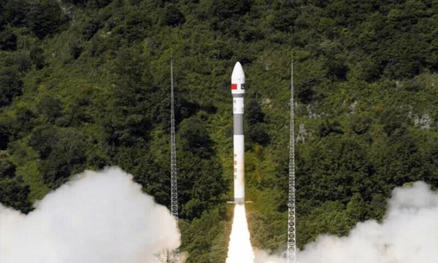
Pakistan’s national space agency SUPARCO successfully sent its advanced Remote Sensing Satellite (PRSS) into orbit from China’s Xichang Satellite Launch Centre (XSLC). The mission marks a pivotal milestone in Pakistan’s ambitious Vision 2047 space roadmap. Equipped with high-performance imaging systems, the PRSS platform will significantly upgrade the nation’s capabilities in precision agriculture, disaster management, infrastructure planning, glacier monitoring, and CPEC geospatial mapping.
-
Launch Date & Site: July 31, 2025, from Xichang Satellite Launch Centre in China — a Chinese Long March rocket placed PRSS in low Earth orbit.
-
Satellite Capabilities: Features upgraded optical imaging sensors for real-time environmental and infrastructure data.
-
Primary Uses: Supports precision agriculture, urban planning, flood/landslide and glacier melt monitoring, and mapping for CPEC projects.
-
National Space Program: Builds on earlier launches—PRSS-1 in 2018, EO‑1 in January 2025—under SUPARCO's Space Vision 2040/2047 initiative.
-
Strategic Alignment: Seamlessly corresponds with the National Space Policy and Pakistan’s goals for scientific and techno-economic uplift by 2047.
-
PRSS will facilitate early detection of floods, landslides, glacial lake outbursts, and earthquake aftermath—enhancing NDMA and PDMA response capabilities.
-
Enables crop yield forecasting, irrigation optimization, and urban planning analysis to help policymakers steer development and resource allocation more precisely.
-
Satellite data supports geospatial intelligence for highway, energy corridor, and industrial zone planning under the CPEC initiative, including hazard identification and project siting.
-
PRSS assists in tracking deforestation, water reservoir levels, and groundwater depletion—integral to national climate resilience strategies.
Regional & International Positioning
-
Pakistan is carving its niche in space-based Earth observation, standing alongside nations like China and India that leverage satellites for development and environmental governance.
Technical & Infrastructure Readiness
-
To leverage PRSS effectively, Pakistan must scale ground infrastructure: satellite ground stations, GIS databases, and real-time processing capabilities.
Economic Viability & ROI
-
High-resolution imaging is costly; many users still rely on commercial providers. PRSS data must be accessible to domestic agencies and startups to justify operational costs.
Pakistan’s successful launch of the advanced PRSS satellite is a landmark moment in its space journey—hybridizing international cooperation with national ambition. The mission promises to transform Pakistan’s abilities in environmental monitoring, disaster response, and development planning. However, the real impact will depend on accessible infrastructure, public-private partnerships, and institutional application.